FEMA Flood Maps for Worland, Wyoming
The FEMA Flood Map for Worland, Wyoming is number 56043C0439D, effective on 3/2/09 can be found here:
http://msc.fema.gov/portal/search?AddressQuery=worland%2C%20wyoming#searchresultsanchor
The FEMA Letter of Flood Map Revision 12-08-0535P-560089, effective 7/1/13 can be found here, which includes aerial photos, diagrams, maps, etc.:
http://map1.msc.fema.gov/data/56/L/12-08-0535P-560089.pdf?LOC=32f88e4ead78ee86e7e2ff360fb872e8
Showing posts with label Washakie County Maps. Show all posts
Showing posts with label Washakie County Maps. Show all posts
Monday, March 7, 2016

Cost of Living, Crime Rates in Worland, Land Management Maps
Areavibes.com:
http://www.areavibes.com/worland-wy/weather
Salaryexpert.com:
http://www.salaryexpert.com/costoflivingdata/city/worland-wy
Citydata.com (forums on moving to, etc.):
http://www.city-data.com/forum/wyoming/569784-moving-worland-wy.html
Washakie Development Association:
WDA can assist private businesses with business relocation and business expansion in Worland, Ten Sleep, and the rest of Washakie County through business relocation incentives and business ready grant programs. We also have one of the newest industrial parks in Wyoming and railroad access.
Washakie County has the most diversified economy in the State of Wyoming on a per capita basis. Washakie County also boasts a low cost of living, low taxes, a business friendly tax structure and world-class telecommunications capabilities.
P.O. Box 228
Worland, WY 82401
Ph: (307) 347-8900
http://www.washakiedevelopment.com
Washakie County Profile:
http://www.washakiedevelopment.com/uploads/pdfs/washakie_cty_profile.pdf
Washakie County Maps:
Washakie County is located in the Big Horn Basin in northwest Wyoming. Washakie County is on the western edge of the southern Big Horn Mountains and east of Yellowstone National Park. U.S. 16 and U.S. 20 intersect in downtown Worland. U.S. 16 intersects with I-25 and I-90 on the east side of the Big Horn Mountains, about 60 miles east of Ten Sleep.
http://www.washakiedevelopment.com/index.php?page=location
Washakie County Maps:
http://eori.wygisc.org/#

http://explorer.geospatialhub.org/geoportal/catalog/search/resource/details.page?uuid={6246093C-91CE-4E80-A1D7-CADD66978203}


 This map has land management on it.
Yellow is managed by the BLM.
Blue is managed by the State of Wyoming.
Orange is the Wind River Reservation.
The tan outlines are for Wilderness Study Areas which are managed by the BLM.
Pale Green is managed by the National Forest Service
Dark green is managed by the State of Wyoming Game and Fish
Pale yellow is managed by the Bureau of Reclamation.
http://www.areavibes.com/worland-wy/weather
Salaryexpert.com:
http://www.salaryexpert.com/costoflivingdata/city/worland-wy
Citydata.com (forums on moving to, etc.):
http://www.city-data.com/forum/wyoming/569784-moving-worland-wy.html
Washakie Development Association:
WDA can assist private businesses with business relocation and business expansion in Worland, Ten Sleep, and the rest of Washakie County through business relocation incentives and business ready grant programs. We also have one of the newest industrial parks in Wyoming and railroad access.
Washakie County has the most diversified economy in the State of Wyoming on a per capita basis. Washakie County also boasts a low cost of living, low taxes, a business friendly tax structure and world-class telecommunications capabilities.
P.O. Box 228
Worland, WY 82401
Ph: (307) 347-8900
http://www.washakiedevelopment.com
Washakie County Profile:
http://www.washakiedevelopment.com/uploads/pdfs/washakie_cty_profile.pdf
Washakie County Maps:
Washakie County is located in the Big Horn Basin in northwest Wyoming. Washakie County is on the western edge of the southern Big Horn Mountains and east of Yellowstone National Park. U.S. 16 and U.S. 20 intersect in downtown Worland. U.S. 16 intersects with I-25 and I-90 on the east side of the Big Horn Mountains, about 60 miles east of Ten Sleep.
http://www.washakiedevelopment.com/index.php?page=location
Washakie County Maps:
http://eori.wygisc.org/#

http://explorer.geospatialhub.org/geoportal/catalog/search/resource/details.page?uuid={6246093C-91CE-4E80-A1D7-CADD66978203}

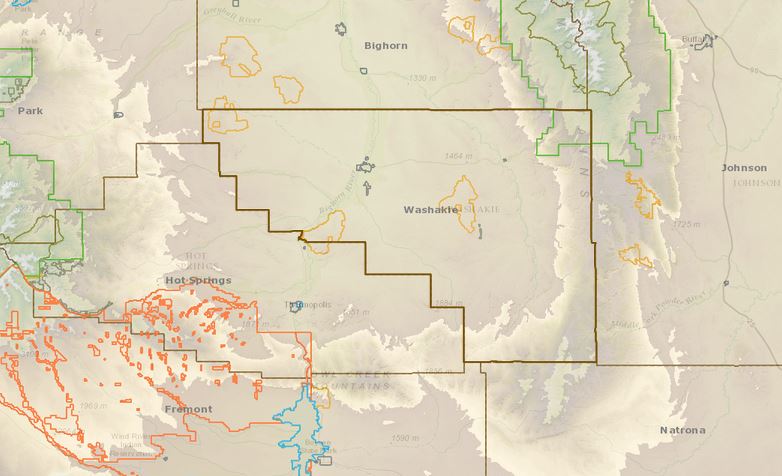

Yellow is managed by the BLM.
Blue is managed by the State of Wyoming.
Orange is the Wind River Reservation.
The tan outlines are for Wilderness Study Areas which are managed by the BLM.
Pale Green is managed by the National Forest Service
Dark green is managed by the State of Wyoming Game and Fish
Pale yellow is managed by the Bureau of Reclamation.
Subscribe to:
Posts (Atom)